Big Sister 156525 Scramble on 18-Jul-2025
Participants: Scott, Stephanie, Matthew
Total stats: 7.54km, 1324m elevation gain, and time to completion 7h10min
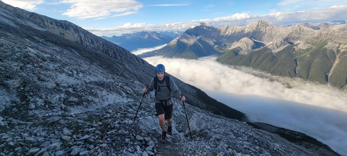
The group started out early with a 5:45am meetup at the trailhead to avoid the threat of thunderstorms being predicted later in the day. We started out in what looked like a thick fog, but as soon as we rose out of the trees, we discovered that is was an inversion cloud, which made for some stunning photos, as you can see Matt making his way on the trail with the inversion below him. To our surprise the inversion cloud covered all of the Bow valley, it was certainly a sight to see.
As we made our way along the trail trying to stick as close to the ridge as possible, we found that this offered the best rock. The trail is very well marked with lots of fresh flagging and cairns marking the way. On our way up we took note of some alternate possible descent routes, which would speed our way back down to the vehicles.
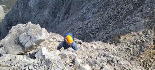
The hike up to the crux is a long one, with lots of slab to go up and across, which at times slowed our progress, but overall was very good. We made it to the crux (the downclimb) just as the sun hit the mountain face, which was a warm welcome (mostly for Stephanie's hands). The crux posed little problems as the rock was excellent, with lots of solid hand and footholds, but caution should still be exercised.
Once past the downclimb, it was back up again to make the final push to the summit, with one last rock to make our way up. The views on the summit were spectacular and the inversion lifted, offering us a sunning view of Spray Lakes.
A photo of Scott making his way back up the crux once coming down from the summit.
After some time at the summit, we made our way back down. This time needing to take extra precaution because much of the slab now had moisture and ball bearing rock on it. As a result, we chose to take as much of a scree path as possible, sticking to the left and just below the slab, but against the wall for stability. We crossed back over to the main trail, which again is well marked with flags and cairns. After the final downclimb we once again, found an alternate decent route, which bypassed much of the downward sloping and now wet slab. To our pleasant surprise this took us to the left of our trail, but through a lovely path in the trees, to the lower creek bed, which we were able to follow all the way back to our cars.
We made it down just after 1pm.


